Introduction
The 2021 Rural-Urban Classification (RUC) is a system used to categorise geographical areas within England and Wales based on the form and characteristics of the settlements present within them. It was published in March 2025 but is based on information from the 2021 Census. The ONS produced the RUC with input from Defra.
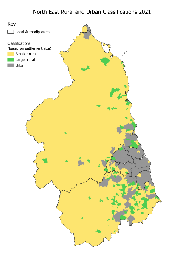
A basic rural or urban classification is given to each Census Output Area (OA), based on whether the majority of residents live in an amalgamated built up area (ABUA):
- Urban: the majority live in ABUAs with a population of 10,000 plus.
- Larger rural: the majority live in ABUAs with fewer than 10,000 residents. These include small towns and low density fringes of conurbations.
- Smaller rural: an area dominated by smaller villages, hamlets and isolated dwellings.
The map in the second tab shows this classification in the North East.
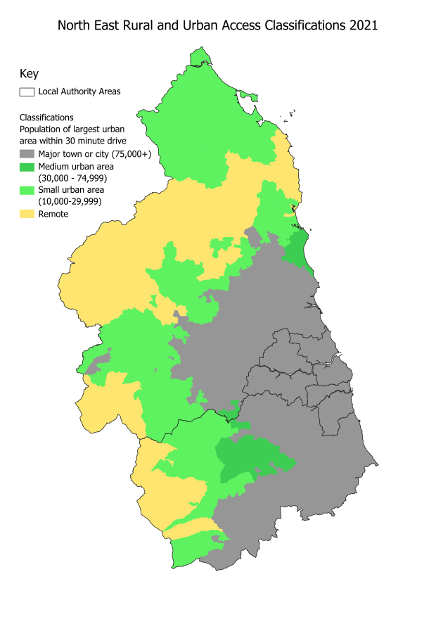
Each Census Output Area has also been given a "relative access" classification:
- Nearer to a major town or city: the majority of the population can access a built up area with a population of 75,000 plus within 30 minutes by car
- Further from a major town or city: the majority are more than 30 minutes drive away from such a built up area.
A detailed classification divides the second of these groups into three, depending on the size of the largest built up area within 30 minutes drive:
- Nearer to a medium urban area: the most populated built up area within 30 minutes drive has 30,000 to 74,999 residents
- Nearer to a small urban area: the most populated built up area within 30 minutes drive has 10,000 to 29,999 residents
- Remote: there is no urban areas of 10,000 plus people within 30 minutes drive.
The map in the third tab shows how the four relative access classifications and sub-classifications are distributed across the North East.
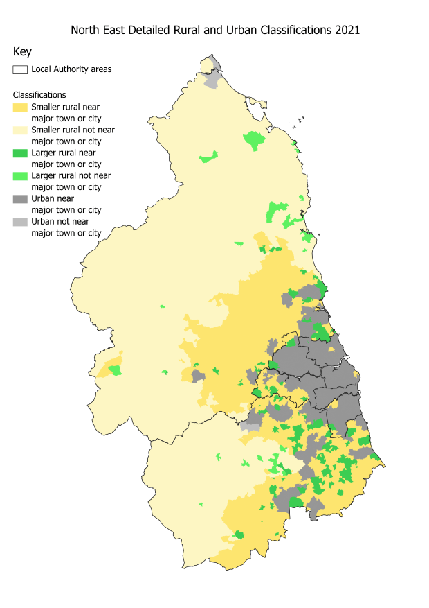
A six part classification can be produced by combining the three rural and urban classifications with the two headline relative access classifications. The North East map for this is shown in the fourth tab.
Rural and Urban Map
Relative Access Map
Rural and Urban and Access Map
Comparisons by area
90%
of North East area is rural
Higher than England excl. London (84%).
85% made up of smaller rural settlements,
Higher than England excl. London (79%).
97%
of Northumberland area is rural
89% of County Durham,
51% of Gateshead,
17% of Newcastle,
9% of Sunderland.
64%
of N.E. area far from major town/city
> 30 minute drive away.
Higher than England excl. London (44%).
77% in Northumberland,
48% in County Durham.
28%
of N.E. area classified as remote
> 30 minute drive from any urban area
Higher than England excl. London (6%).
36% in Northumberland,
16% in County Durham.
Population comparisons
20%
of North East population is rural
(live in a rural area)
Almost 400,000 people (Census 2021)
Same % as England excl. London,
almost 7% in smaller rural settlements.
45%
of Northumberland's population is rural
43% of County Durham's population,
8% of Gateshead's population,
almost 4% of Newcastle's population.
6%
of N.E. population far from major town/city
> 30 minute drive away.
Lower than England excl. London (14%).
25% in Northumberland,
7% in County Durham.
0.7%
of N.E. population in remote areas
> 30 minute drive from any urban area.
Higher than England excl. London (0.4%).
3.8% in Northumberland,
0.4% in County Durham.
Further analysis
This initial report provides the headline North East percentages for total land areas and 2021 census population totals, broken down into rural, urban and relative access classifications. Future reports will provide information about the characteristics of rural residents and how they compare to the characteristics of urban residents. Much of this information will be based on responses to the 2021 Census.
Each LSOA and MSOA in the North East has been classified using the same system as for Census output areas. These two sets of classifications can be combined with datasets available at these geographical levels to provide further rural and urban comparisons. Examples include rural and urban business counts and employee numbers by sector. Links to these reports will be available from this section, which currently includes links to original data sources.
Rural Urban Classification data source
The ONS landing page for information about the 2021 rural and urban classifications, published in March 2025.
Rural Urban Classification download
The National Statistics geoportal page for these classifications
Nomis Census 2021 data page
The nomis website provides downloads of user defined datasets. The Census data is available for each OA and can be combined with rural and urban classifications to compare the characteristics of individuals and hsouseholds in different tyeps of area.